We want to tell a single story but follow three separate crises.
One began deep in Cross River National Park, where a reporter HumAngle worked with walked into the reserve and found neat rows of cocoa where there should have been rainforest in Nigeria’s South South. Another began hundreds of kilometres in the country’s North East, where families in Yusufari, Yobe State, were leaving their homes because sand had overtaken them. The last came from a file we had kept alive for years — the Great Green Wall, Africa’s 8,000-kilometre chain of trees planted to hold the desert back.
With rising interest in Nigeria’s environmental and climate crisis, HumAngle has drawn from its pioneering experience using geospatial investigative techniques to strengthen its reporting and also provide insights to other reporters who want to make sense of the data they gather. These tools and techniques became central to uncovering evidence from the aforementioned stories.
At first, they felt unrelated. One was about farms, another about migration, the third about a wall of trees. But as the maps were laid out, aligned on the satellite imagery, and compared with the testimonies of locals and experts in the field, the three began to move as one. Forests are collapsing in the south, deserts are pressing from the north, and the only defence is a broken wall.

Righteous deforestation
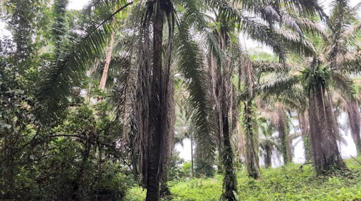
The first set of coordinates dropped us in the dense green. From above, the forest around Ekong/Oban town in Cross River State looked alive and whole. But zooming closer, the stylish spiral shapes of the tree canopies looked different from the bushy, round type of the natural rainforest tree crowns. Natural forest crowns scatter randomly, and the spirals reveal human hands. Cocoa.
“There are a lot of farms in the area, though, which have also sprung up in the same time period,” said Olatunji Olaigbe, the investigative reporter on the ground. “One thing we heard happens is that virgin forest is logged, and then the cocoa farmers plant on it after a while and claim farms have always been there.”
Olatunji’s GPS confirmed it. He had stood among young cocoa trees where laws say there should be natural rainforest. In fact, he had walked more than one farm, and locals told him there were many like the ones he had seen. To verify, we scanned further and identified two large sites having these same tree crowns as the place where he was.
The first was within walking distance. It covers over 3,000 hectares, with scattered individual patches spreading loosely through the forest. The hypothesis was that they had no formal system of land allocation due to their unstructured organisation. Like a traditional tenure system, where the lands have no visual demarcating boundaries. Likely by villagers from the neighbouring communities. They may endure inherent land crises and disputes. If they did, it may not be apparent from a satellite perspective as the crops spread freely and uninterrupted over the National Reserve.
The second site, a few kilometres south of this site, looked more structured. Covering about 4000 hectares, it was orderly: consistent crops, obvious boundary markers. We suspected that this site may belong to a major entity invested in cocoa farming or a group of individuals and/or entities in agreement. Each owns one or multiple lands, perhaps allocated by an authority.
We then measured how much forest had been lost. By overlaying the Hansen Global Forest Change data on two decades of Landsat imagery, the picture sharpened into a time-lapse of collapse. Between 2010 and 2015, degraded forests were thinned and gave way to deforested land. Stable forest shrank by more than two-thirds. By 2023, what remained of the true natural forest was buried in cultivation and cleared lands.


From above, the canopy still looked thick. But its function was gone. Rainforest exchanged for cocoa no longer serves the same way.
We held on to the impression as we travelled through the country’s North. If Cross River had an abundance of crops at the expense of natural forest, Yusufari was stripped bare of both.
Across dying sands


In Yobe State, reporters spent some weeks travelling across villages surrounded by dunes, such as Yusufari and other villages and towns towards the Nigeria-Niger Republic border, including Bultu Briya, Zakkari, Tulo-Tulo, and Bula-Tura.
When the photos got to the newsroom, the story was immediately obvious. Settlements, where locals were facing severe water shortages, sat on a bright sandy floor. In some communities, children walked kilometres to fetch water, and in some communities, residents packed up and migrated across the border.
We turned to satellite sensors to understand what was happening beneath the sandy surface. Data from the Gravity Recovery and Climate Experiment (GRACE) satellite mission (2002 – 2017), which tracks the Earth’s shifting gravity to measure underground water storage, showed an odd pattern. Across much of the Sahel, from Zinder to northern Borno, Diffa-Yusufari region, and Southern Yobe, groundwater supplies had ticked upward. But Yusufari itself was an outlier: a flat line. No rise, no fall. A dead pulse for two decades.
The land was no better. ESA’s WorldCover maps showed degrading lands with surface water and arable land shrinking. Which is ironic because the land use satellite data we looked at shows that more than 12 per cent of Yobe’s territory is committed to cropland use, which is far higher than neighbouring Borno or Diffa. They were essentially farmers in a dying land unfit for farming. And so many of them decided to escape the advancing deserts.

Another tool, NASA’s Moderate Resolution Imaging Spectroradiometer (MODIS) aboard Terra and Aqua satellites, helped us track changes in vegetation over the past two decades. The sensor’s record of greenness showed that villagers travelling into villages in the Niger Republic and Chad were not escaping the arid zone. Instead, the sand was on their heels, following them across the border.


Holding on to that impression, we examined these environmental crises at both ends of the country. The crises looked different, but the outcome was similar: green was disappearing, whether through natural and man-made exploitation.
In the South, the forest is being consumed under cultivation. Meanwhile, in the North, the soil was consumed until cultivation was impossible. Faced with crises like these, the question is always: what solutions exist?
One answer has been environmental laws that protect forest reserves meant to safeguard natural habitat, but as we have observed in Cross River, these laws are often ignored, with little or no deterrence against exploitation. Another idea was daring to match global-scale desertification with afforestation, hence the idea of the Green Wall.
Launched in 2007, the Great Green Wall promised an 8,000-kilometre shield of vegetation across Africa’s midsection, as wide as a city. A living barrier meant to stop the desert from devouring soil and lives. But, nearly two decades later, what has actually grown is far more complicated.

The broken wall
Reporters who travelled across communities along the Wall’s route in the West African Sahel sent back coordinates that were less precise than in Cross River and Yobe states. Insecurity made movement almost impossible. Many sections of the Green Wall corridor remain under the control of violent non-state armed groups, with villages emptied by displacement.
So we turned to geospatial tools to fill in the gaps, and there was an unexpected paradox. Across the Wall, trees were thriving in those places people had abandoned, but dying in many of the places where people remained or fled to.
To measure this, we cut the corridor into grids — manageable 18-by-18-kilometre boxes spanning thirty localities along the Great Green Wall, from Nigeria, Niger, into Burkina Faso, and beyond. We counted trees in 2007, then again in 2025, using high-resolution mosaics and classification models.
The aggregate number went up. From 3.1 million trees in 2007 to 3.9 million by 2025, a 26 per cent increase. But the growth was concentrated in deserted places.

Across communities in Isa, a local government area in Sokoto State, northwestern Nigeria, insurgency drove villagers away. With grazing and tree-felling halted, and seedlings planted years earlier left undisturbed, tree cover rebounded dramatically — from about 60,000 to nearly 300,000. Dense weeds may have contributed too.
A similar situation unfolded in Burkina Faso’s Djibo, where abandonment allowed trees to flourish. However, in Karma, Niger, tree cover collapsed by more than half.
These contrasting shifts underline the uneven fortunes of the Great Green Wall. Participating countries often report progress; for instance, some media reports say land and vegetation in Senegal and Ethiopia were restored, while Nigeria has claimed five million hectares of reclamation. Yet in rural economies like Yusufari in Yobe or Isa in Sokoto, realities on the ground tell a harsher story. Reporters found Green Wall sites littered with dead seedlings, left untended.
“When I went to Yusufari, I saw that the materials were there, as well as the seedlings, but nobody was taking care of the plants. You just see them dead as you pass by,” Mallam Usman, an environmental journalist, recounted.
Since the 2010s, violent groups across Nigeria’s North West and the Sahel have threatened the Green Wall efforts, especially in villages abandoned by locals. Based on satellite observations, the Wall grew more in places where people could not stay.

The legacy effect
To understand this, we probed further using open-source records of past Green Wall and related projects. A “legacy effect” became clear: seedlings sown years earlier, before villages were abandoned, had matured into trees. Our analysis identified at least eight initiatives across Nigeria, Niger, and Burkina Faso that may have laid this foundation.
We observed the new greens, which are thinner trees with younger trunks and reach. It made sense that 10 to 18-year-old trees would grow within the period of our satellite measurements.
However, for some of these places, like Isa, the growth of a few dense weeds in the abandoned areas was likely captured by the sensors despite their calibration for growing trees.

Table 1: Tree planting initiatives that may have been the legacies growing in deserted areas.
Sources: Synthesis of OSINT research, human testimonies and land cover satellite data extraction. Table: Mansir Muhammed/HumAngle
Reporting the crisis
But numbers and pixels tell only part of the story. Behind every satellite measurement lies a human landscape: communities displaced, farmers abandoning fields, and projects like the Great Green Wall that carry both promise and complication. Capturing this side is harder.
“Reaching the people at the centre of these crises is often difficult,” said Al’amin Umar, HumAngle’s climate reporter, whose work focuses on the human cost of climate change at the intersection of conflict and humanitarian crises.
Yet even as field reporting faces these limits, specialised sensors help trace what is otherwise hidden. We have tracked water stress, deforestation, and migration, with satellite technology detecting environmental markers that reveal unsettling conditions across these regions.
From South to North, the coordinates, the pixels, and testimonies say the same thing: the continent’s edges are eating toward the centre, and the centre — the very wall where we placed our hopes for resilience — is already too skewed to hold.
Field reporting: Ibrahim Adeyemi, Olatunji Olaigbe, Mallam Usman, Al’amin Umar, and Saduwo Banyawa.
All code and data generated for these investigations are available in our open-source project repository.