
1 of 2 | Hurricane Erin has become a Category 5 hurricane as it moves in the Atlantic in a northwestly direction and then turning northward. Tracking by the National Hurricane Center
Aug. 16 (UPI) — Hurricane Erin is now a Category 5 storm, the highest on the class, rapidly intensifying overnight into early Saturday morning as it threatens the Leeward Islands and Puerto Rico, then will move along the U.S. East Coast.
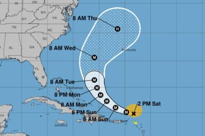
In an update at 11:20 a.m. EDT, the National Hurricane Center reported an Air Force Reserve Hurricane Hunter aircraft showed maximum sustained winds of 160 mph, which passes the 157 mph minimum for Category 5 on the Saffir-Simpson Hurricane Wind Scale.
In the NHC’s 2:00pm update, Erin remained a Category 5 storm with 160 mph after rapidly intensifying from a 75 mph-Category 1 storm on Friday morning to a 155 mph-Category 4 at the 11 a.m. advisory on Saturday morning.
The storm was located approximately 110 miles north of Anguilla and about 205 miles east-northeast of San Juan, Puerto Rico, and was traveling west at 16 mph.
The northern Leeward Islands include Anguilla, Antigua and Barbuda, the British and U.S. Virgin Islands, St. Martin, St. Barts, Saba, St. Eustatius, St. Kitts and Nevis, and Montserrat.
A tropical storm watch remains for St. Martin and St. Barthelemy, and Sint Maarten. Hurricane-force winds extend up to 30 miles from the center and tropical-force outward to 140 miles.
The storm is expected to skirt the Leeward Islands and Puerto Rico on Sunday rather than hit them directly, which could bring strong winds and up to 6 inches of rain through the day Saturday.
“Locally considerable flash and urban flooding, along with landslides or mudslides, are possible,” NHC said, in addition to the possibility of swells.
“Swells generated by Erin will affect portions of the northern Leeward Islands, the Virgin Islands, Puerto Rico, Hispaniola, and the Turks and Caicos Islands through the weekend,” the weather service said in its latest update. “These swells will spread to the Bahamas, Bermuda, and the East Coast of the United States early next week.
“These rough ocean conditions will likely cause life-threatening surf and rip currents.”
Forecasters are predicting the storm will make a west-northwest turn Saturday evening, which will come with a “decrease in forward speed,” ahead of an expected northerly early next week.
By Wednesday night, the storm was forecast to be a few hundred miles west of Bermuda and just outside the big tracking cone. Erin then is forecast to travel north hundreds of miles from the East Coast.
Forecasters predict the storm has the potential to affect the U.S. East Coast, including Florida, as well as the Bahamas and Bermuda, next week.
“Erin is expected to produce life-threatening surf and rip currents along the beaches of the Bahamas, much of the East Coast of the U.S., and Atlantic Canada next week,” NHC forecaster Jack Beven said in a discussion.
Erin became the first hurricane of the 2025 Atlantic storm season Friday. Forecasters had been expecting the storm to intensify into a hurricane since early in the week.
There have been four prior Atlantic named storms so far this season. Tropical Storm Chantal caused major flooding in North Carolina but was the only of the four to make landfall in the United States.
The Atlantic hurricane season began on June 1 and ends on Nov. 30. The peak hurricane season goes from mid-August through September and into mid-October. Ninety-three percent of hurricane landfalls along the U.S. Gulf Coast and the East Coast have occurred from August through October, the Weather Channel reported in citing data from the National Oceanic and Atmospheric Administration
Last year at this time, there also had been five named storms.