Hurricane Erin was expected to bring tropical storm conditions to North Carolina on Wednesday evening and Virginia on Thursday. Photo courtesy of the National Oceanic and Atmospheric Administration
Aug. 20 (UPI) — The outer bands of Hurricane Erin neared North Carolina’s Outer Banks on Wednesday evening, prompting the National Hurricane Center to issue warnings against swimming at most East Coast beaches.
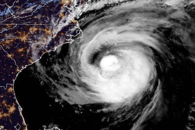
The Category 2 storm, described as “large” by the NHC, had maximum sustained winds of 110 mph, just shy of a Category 3 hurricane. The eye of the storm was located about 490 miles west of Bermuda and 245 miles south-southeast of Cape Hatteras, N.C., and was moving north at 14 mph, according to the NHC’s 8 p.m. update.
A storm surge warning was in effect for from Cape Lookout to Duck, N.C., while a tropical storm warning was in effect for Beaufort Inlet, N.C., to Chincoteague, Va., including Pamlico and Albemarle Sounds.
Bermuda was under a tropical storm watch.
“Erin is expected to produce life-threatening surf and rip currents along the beaches of the Bahamas, much of the east coast of the U.S., Bermuda and Atlantic Canada during the next several days,” the NHC said. “Beachgoers in those areas should follow advice from lifeguards, local authorities and beach warning flags.”
Forecasters warned weather conditions were expected to deteriorate along the Outer Banks late Wednesday into Thursday. Storm surge and large waves could cause beach erosion and make some roads impassible.
Tropical storm conditions were expected to reach the Virginia coast Thursday and farther north through early Friday.
The season’s first Atlantic hurricane reached Category 5 status Saturday morning, the highest classification, after rapidly intensifying overnight Friday, when it became a Category 1 hurricane, the year’s fifth named storm.
Erin dropped to a Category 4 and then a 3 overnight into Sunday, but regained Category 4 strength late Sunday before again losing strength.
Erin became the first hurricane of the 2025 Atlantic storm season Friday morning.
There have been four named storms so far this season in the Atlantic. Tropical Storm Chantal caused major flooding in North Carolina but has been the only one of the four to make landfall in the United States this year.
The Atlantic hurricane season began on June 1 and ends on Nov. 30. The peak hurricane season runs from mid-August through September and into mid-October.
Ninety-three percent of hurricane landfalls along the U.S. Gulf Coast and the East Coast have occurred from August through October, the Weather Channel reported, citing data from the National Oceanic and Atmospheric Administration
Last year at this time, there had also been five named storms.