Hurricane Erin is expected to make a turn toward the north and northeast, skirting the Atlantic coast of the United States. Photo courtesy of the National Oceanic and Atmospheric Administration
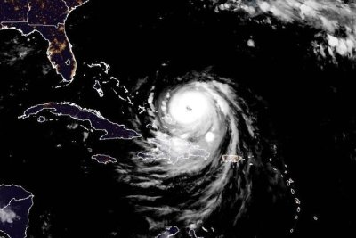
Aug. 18 (UPI) — Hurricane Erin’s outer bands were beginning to lash the southeast Bahamas and the Turks and Caicos Islands early Monday after regaining Category 4 strength overnight.
The storm was located about 110 miles northeast of Grand Turk Island and 935 miles south-southeast of Cape Hatteras, N.C., the National Hurricane Center said in its 2 a.m. AST update.
It was moving northwest at 12 mph and was packing maximum sustained winds of 130 mph.
Forecasters are warning of life-threatening surf and rip currents across the eastern United States this week.
The season’s first Atlantic hurricane reached Category 5 status Saturday morning, the highest classification, after rapidly intensifying overnight. It became a Category 1 hurricane on Friday, the year’s fifth named storm.
Erin dropped to a Category 4 and then a 3 overnight into Sunday, but regained Category 4 strength late Sunday.
“Since the large-scale environment is expected to be favorable for about another day, re-strengthening is possible during that time period,” NHC forecaster John Cangialosi said. “However, it should be noted that predicting the intensity evolution from internal dynamics are challenging, and models often provide Little reliability in their solutions.”
The storm was skirting Puerto Rico overnight rather than hitting it directly.
On the forecast track, Erin’s core is projected to pass to the east and northeast of the Turks and Caicos Islands and the southeastern Bahamas over Monday, and then move between Bermuda and the U.S. east coast by the middle of the week
Erin’s outer bands will produce additional rainfall of 2 to 4 inches across the Virgin Islands and Puerto Rico, with isolated totals of up to 8 inches through Monday. “Locally considerable flash and urban flooding, along with landslides or mudslides, are possible,” the NHC said.
Also, swells will affect those places, as well as Hispaniola and the Turks and Caicos Islands, during the next couple of days, the agency said.
“Erin is expected to produce life-threatening surf and rip currents along the beaches of the Bahamas, much of the East Coast of the U.S., Bermuda, and Atlantic Canada during the next several days,” Cangialsi said.
He said interests along the North Carolina and mid-Atlantic coasts, as well are Bermuda “should monitor the progress of Erin as there is a risk of strong winds associated with the outer rainbands during the middle of next week.”
Alex Sosnowski, AccuWeather senior meteorologist, said portions of North Carolina’s Outer Banks and coastal Virginia will experience several feet of storm surge, leading to significant coastal flooding and beach erosion.
He said the closest landmass for Erin to hit could be southeastern Newfoundland in Canada on Friday.
Erin became the first hurricane of the 2025 Atlantic storm season two days ago.
There have been four named storms so far this season in the Atlantic. Tropical Storm Chantal caused major flooding in North Carolina but has been the only one of the four to make landfall in the United States this year.
The Atlantic hurricane season began on June 1 and ends on Nov. 30. The peak hurricane season runs from mid-August through September and into mid-October.
Ninety-three percent of hurricane landfalls along the U.S. Gulf Coast and the East Coast have occurred from August through October, the Weather Channel reported in citing data from the National Oceanic and Atmospheric Administration
Last year at this time, there had also been five named storms.
The U.S. East Coast is forecast to have rough ocean conditions through the middle of the week as the storm strengthens, the National Hurricane Center said. Tropical storm warnings were issued for the southeast Bahamas, about 300 miles east of Miami, and Turks and Caicos Islands.