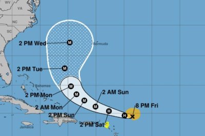

1 of 2 | Hurricane Erin is forecast to become a major hurricane by 2 a.m. Sunday. Tracking by the National Hurricane Center
Aug. 15 (UPI) — Erin became the first hurricane of the 2025 Atlantic season on Friday morning and is forecast to rapidly strengthen as it heads near the Leeward Islands, and later Puerto Rico and the Virgin Islands.
In its 10 a.m. EDT update, the National Hurricane Center said Erin became a hurricane with maximum sustained winds of 75 mph — just 2 mph above the tropical storm designation.
In the 7 p.m. update, Erin increased to 85 mph.
Erin was 310 miles east of the Northern Leeward Islands, and was moving west-northwest at 17 mph in warm waters.
The NHC said the motion is expected to continue through the weekend with some decrease in forward speed.
With rapid strengthening the next two to three days, Eric is forecast to become a major hurricane during the weekend with winds at least 111 mph.
On the forecast track, Erin is likely to go just north of the Northern Leeward Islands, the Virgin Islands and Puerto Rico over the weekend. Erin is forecast to reach Category 4 at 130 mph on Monday, the NHC said.
By 2 p.m., Wednesday, the storm was forecast to be a few hundred miles west of Bermuda and outside the big tracking cone.
“While the threat of direct impacts in the Bahamas and along the East coast of the United States appears to be gradually decreasing, there will still be a significant risk of dangerous surf and rip currents along western Atlantic beaches next week,” NHC forecaster Jack Beven wrote in a discussion.
Tropical storm warnings remain in effect for Anguilla St. Martin and St. Barthelemy, Saba and St. Eustatius, and Sint Maarten.
Hurricane-force winds extend up to 75 miles from the center, and tropical-force winds outward to 115 miles.
Marine warnings are in effect for the Atlantic, Caribbean and southwest Atlantic and the southwest North Atlantic.
The NHC said Puerto Rico and the northern Leeward Islands — which include Anguilla, Antigua and Barbuda, the British and U.S. Virgin Islands, St. Martin, St. Barts, Saba, St. Eustatius, St. Kitts and Nevis, and Montserrat — should expect heavy rainfall Friday night through Sunday. Rainfall totals of 2 to 4 inches are forecast with isolated totals of 6 inches. It could lead to flash and urban flooding, along with landslides and mudslides.
Swells will begin affecting this area and will spread to the western Atlantic next week.
Wind gusts or tropical storm-force winds are possible in rainbands over portions of the Virgin Islands and Puerto Rico this weekend.
“Do not underestimate the power of a major hurricane even passing by offshore,” Alex DaSilva, the lead hurricane expert with AccuWeather, said. “These massive storms produce very rough surf and lethal rip currents that can impact beaches even hundreds of miles away.”
The previous four named Atlantic storms this year were Andrea, Barry, Chantal and Dexter. None of them became hurricanes, and Chantal was the only one to make landfall in the United States, causing significant flooding in North Carolina.
Helene struck that state last year as a tropical storm, causing an estimated $53 billion in damage, after hitting western Florida as a Category 4 hurricane.
Four other hurricanes made landfall in the United States in 2024: Beryl, Debby, Francine and Milton.