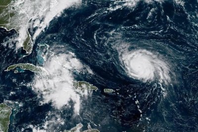
1 of 3 | Hurricane Humberto, right, remained a major hurricane on Saturday morning, while Tropical Depression Nine, left, is forecast to become Tropical Storm Imelda by Sunday morning. Photo courtesy of the NOAA
Sept. 27 (UPI) — Humberto weakened to a Category 4 hurricane Sunday, but remains a threat to the East Coast and Bermuda this week, the National Hurricane Center said.
Humberto had maximum sustained winds of 145 mph, was located about 525 miles north-northwest of the Northern Leeward Islands and about 470 miles south-southeast of Bermuda, and was moving west-northwest at 10 mph, the National Hurricane Center reported in its 5 p.m. EDT update.
Hurricane-force winds extend outward up to 25 miles from the center of the storm, and tropical-force winds to 125 miles outward.
No coastal watches or warnings are in effect, but the NHS advises officials in Bermuda to monitor Hurricane Umberto’s progress.
Hurricane Humberto likely will retain its major hurricane status for the next several days and turned to the northwest on Sunday, and is projected to make another turn to the north by Tuesday, according to the NHC.
Swells generated by Humberto will start affecting portions of the northern Leeward Islands, the Virgin Islands, Puerto Rico and Bermuda beginning Sunday night, where the hurricane likely will cause life-threatening surf and rip current conditions.
The NHC shows Bermuda in the storm’s cone on Tuesday.
Humberto is the eighth named storm of the Atlantic season and became the season’s third hurricane on Friday morning.
Tropical Depression Nine could threaten southeastern U.S.
The NHC also is tracking Tropical Depression Nine on Saturday morning and expects it to strengthen to tropical storm status by late Saturday night, which would be named Tropical Storm Imelda.
The tropical depression had maximum sustained winds of 35 mph and was moving northwesterly at 5 mph while located about 200 miles northwest of the eastern tip of Cuba and about 105 miles south-southwest of the Central Bahamas, according to the NHC’s 5 p.m. EDT update.
“Strengthening is expected during the next few days, and the system is forecast to become a tropical storm tonight or early Sunday and a hurricane by late Monday or Tuesday,” the NHC update said.
A tropical storm watch was issued for Florida’s east coast from the Palm Beach/Martin County line north to Flagler/Volusia County line.
A tropical storm warning is in effect for the Central Bahamas and San Salvador, while a tropical storm watch is in effect for portions of the northwest Bahamas.
Moving north-northwest through Monday, the storm is expected to track across the central and northwestern Bahamas on Sunday and approach the U.S. coast early next week, according to the NHC.
Eastern Cuba is expected to see 8 to 12 inches of rain with the potential for up to 16 inches in isolated areas, while the Bahamas is predicted to see 4 to 8 inches of rain, forecasters said.
Between 2 and 4 inches of rain is forecast across Hispaniola, Jamaica, and portions of central and southern Cuba.
“This rainfall will likely produce flash and urban flooding,” NHC said. “Mudslides are also possible in areas of higher terrain across eastern Cuba, Hispaniola and Jamaica.
Swells generated by the cyclone, as well as Hurricane Humberto, will affect parts of the Bahamas this weekend and are predicted to spread to the southeast U.S. coast early next week.
The potential for swells could cause life-threatening surf and rip current conditions, NHC said.