Rain could fall for 10 days straight along the New South Wales coast as weather systems over southern Australia grind to a standstill.
The prolonged drenching will result from a “blocking high”, the name given to a high-pressure system that stalls from several days to several weeks, and blocks the typical eastward movement of weather.
This stalling of pressure systems removes the standard day-to-day variability typically experienced in mid-latitude climates like Sydney, leading to an extended spell where the weather is almost identical each day.
While some blocks lead to warm and sunny weather, this week’s pattern will bring cool and showery weather to the NSW coast, intensifying into areas of heavy rain this weekend which may even culminate in another bout of flooding.
Loading…
Why the weather chart appears frozen
The seemingly jammed-up weather map is due to the unusual behaviour of the jet streams, fast-moving ribbons of air around 10 kilometres above the Earth’s surface.
There are two jet streams in each hemisphere, a polar stream and a subtropical one, eternally circumnavigating the poles from west to east.
While the Southern Hemisphere’s subtropical jet characteristically blows laterally at around 30 degrees latitude, the polar jet displays a wave formation and bends north and south with each passing cold front.
During the cooler months the polar jet often migrates far enough north to connect with the subtropical jet, however this week, the two jet streams have split to the west of Western Australia – the subtropical jet has shifted slightly north to around 25 degrees latitude, cutting right through the centre of Australia, while the polar jet has dived well south to the Antarctic coastline.
This separation of up to 4,000km has created a considerable void between the streams where there is little wind aloft to keep weather systems mobile, allowing a high-pressure system south of Australia to become cradled in one place.
Loading…
The stalling high will also strengthen to near record levels, with modelling indicating a central pressure up to 1043 hPa midweek, and the stronger the high, the stronger the winds required to move it — for reference, the highest pressure ever recorded in Australia was 1044 hPa at Launceston in June 1967.
All up, the high should take around eight days to move from WA’s longitudes to Tasmania, then possibly another week to reach New Zealand — a fortnight-long journey which just last week was completed by a weaker high in just three days.
Location, location, location – high’s position brings week of rain
The critical aspect of what weather a blocking pattern brings is its place relative to a given location.
Winds blow anti-clockwise around high-pressure systems and its location below the Bight will ensure south to south-easterly winds prevail across south-east Australia – onshore and showery for eastern NSW, and cross-shore or offshore for most other coastlines.
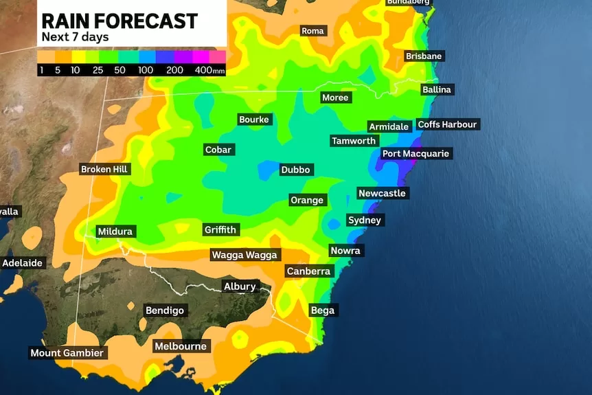
The showers initially will not generate heavy falls or severe weather, however when combined with a developing trough later this week, an area of rain will form across western NSW on Thursday and Friday, shifting to the coast during the weekend.
Modelling indicates the event could bring anything from 50 to 200 millimetres to the NSW coastline, and possibly over 50mm across pockets of the west, potentially enough to trigger flood watches and warnings.
Sydney’s heaviest rain is likely from Saturday to Monday, and it would be no surprise if the city’s weekly total exceeded 100mm and even passed the May average of 117mm by this time next week.
The pattern has similarities to the flood event earlier this month, however on that occasion the atmosphere was fully loaded with moisture due to a north-easterly off the warm Coral and northern Tasman seas.

On this occasion winds from the south or south-east contain less moisture and hopefully less rain, however the wildcard is the coastal trough deepening into a low-pressure system.
Under the coastal low set-up, which some models are hinting at, warmer and moister air will wrap into the system from the north, leading to hundreds of millimetres of rain and possibly major flooding — but thankfully this worst-case scenario is currently only an outside chance.