Tropical Storm Erin is forecast to become a hurricane by 8 a.m. Friday and a major one by 8 p.m. Sunday. Image by National Hurricane Center
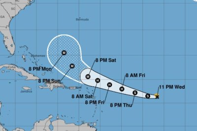
Aug. 13 (UPI) — Tropical Storm Erin is slightly intensifying and forecast to become a hurricane on Friday morning over the central tropical Atlantic with a chance of ultimately affecting the U.S. East Coast, the Bahamas and Bermuda next week, the National Hurricane Center said Wednesday.
For the first time since Erin became a tropical storm Monday morning, intensity increased, though just 5 mph, to maximum sustained winds of 45 mph, with gradual strengthening during the next two days forecast, the NHC said in its 5 p.m. EDT update.
In the 11 p.m. update, Erin remained at 50 mph.
Erin is forecast to reach hurricane status by 8 a.m. Friday with winds at least 74 mph, and a major hurricane, with winds of at least 111 mph, by 8 p.m. Sunday.
It would be the first hurricane of the Atlantic season. Beryl was the first hurricane last year on June 24.
The storm is about 1,095 miles east of the Northern Leeward Islands.
Erin was moving westward at 16 mph and will shift to a north-westward track beginning Thursday night and into the weekend, the NHC said. On the forecast track, the storm’s center will move over or near just north of the northern Leeward Islands.
The NHC’s “cone” doesn’t track Erin past Monday night, and NHC forecasters remind that they have an average error of 150 to 214 miles at days four and five.
In the latest discussion, NHC forecaster Jack Beven said there is a “greater than normal uncertainty about what impacts Erin may bring to portions of the Bahamas, the East Coast of the United States and Bermuda.”
But he said: “The risk of dangerous surf and rip currents across the western Atlantic basin next week is increasing.”
By this weekend, swells are forecast to cause life-threatening surf and rip current conditions, the NHC said.
Alex Sosnowsky, an AccuWeather senior forecaster, said there is concern that residents, visitors, cruise lines, and shipping and fishing ventures “could pass paths with a powerful hurricane.”
With a track farther to the east, Bermuda could be directly in the path as a major hurricane.
He said a farther west scenario would mean a greater risk of strong winds, rain and coastal flooding in the U.S., including eastern North Carolina, Long Island, New York and southeastern New England.
“Families heading to U.S. Atlantic beaches for a late-summer vacation next week need to be extremely cautious when venturing into the surf,” AccuWeather Lead Hurricane Expert Alex DaSilva said. “More than 50 people have lost their lives to rip currents and rough surf at beaches across the country so far this year, without any major hurricane nearby.”
There are no warnings or coastal watches in effect as tropical-force winds extend outward up to 60 miles. But those in the northern Leeward Islands, the Virgin Islands and Puerto Rico should monitor Erin’s progress.
The previous four named Atlantic storms this year were Andrea, Barry, Chantal and Dexter. None of them became hurricanes, and Chantal was the only one to make landfall in the United States, causing significant flooding in North Carolina.
Helene struck that state last year as a tropical storm, causing an estimated $53 billion in damage, after hitting western Florida as a Category 4 hurricane.
Four other hurricanes made landfall in the United States in 2024: Beryl, Debby, Francine and Milton.