Kiko

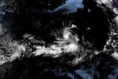
Hurricane Kiko steadily weakens as it moves toward Hawaii

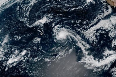
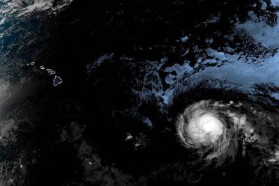
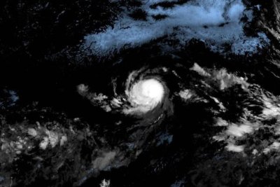
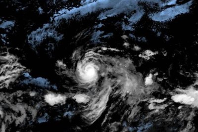
Hurricane Kiko, shown here off the coast of Hawaii, has been downgraded to a Category 1 storm, and is likely to pass north of the islands. Photo courtesy of NOAA

Sept. 9 (UPI) — Hurricane Kiko was steadily weakening on Monday but remained a Category 1 storm, according to forecasters who predict it will pass north of the Hawaiian Islands in the next two days.

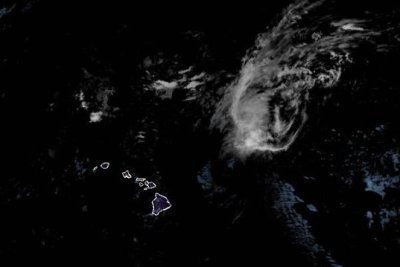
The storm had maximum sustained winds of 75 mph and was located about 300 miles east-northeast of Hilo, Hawaii, and 450 miles east of Honolulu, the National Hurricane Center said in its 5 p.m. HST update.

It was moving northwest at 14 mph, the center said.

On the forecast track, Kiko was expected to pass north of the Hawaiian Islands on Tuesday and Wednesday, the NHC said.

However, swells generated by the storm were gradually building from east to west across Hawaiian waters and are expected to peak Monday night through Wednesday.

“While the risk of direct impacts on the islands continues to decrease, interests should continue to monitor Kiko’s progress and the latest forecasts,” the NHC said in a discussion on the storm

The forecasters said they expect the storm to be downgraded to a tropical storm overnight.

Kiko had intensified to a Category 4 hurricane early last week, but was later downgraded as it weakened off the coast.

No watches or warnings were in place, the NHC said.

Source link

Hurricane Kiko may miss Hawaii but ‘life-threatening’ surf still likely

1 of 2 | Hurricane Kiko, shown off the coast of Hawaii, has been downgraded to a Category 3 storm, and is likely to pass north of the islands early this week. Photo courtesy of NOAA.

Sept. 7 (UPI) — Hurricane Kiko, packing winds in excess of 110 mph, is forecast to approach the Hawaiian islands early this week, but is predicted to pass to the north, meteorologists said Sunday.

“The forecast track currently for Kiko is to pass north of Hawaii,” the National Weather Service said in a public advisory on social media. “It is still too soon to determine the exact location/magnitude of potential impacts from Kiko. Interests in the island should continue to monitor Kiko’s progress.”

As of Sunday morning, the Category 3 storm was about 715 miles east of Hilo and moving to the west-northwest at about 13 mph, generating what forecasters said could be life-threatening surf in the Hawaiian islands.

Kiko had intensified to a Category 4 hurricane early last week, but was later downgraded as it weakened off the coast. Forecasters said it could degrade into a Tropical Storm by Tuesday, but will still be capable of creating heavy rain, gusty winds and dangerous surf through the first half of the week.

There are currently no watches or warnings in place, the NHC said.


Source link

Hurricane Kiko remains a Category 3, tracks toward Hawaii

Hurricane Kiko was expected to continue on the path toward the Hawaiian Islands over the next several days, but it’s unclear to what extent it might impact the state. Photo courtesy of National Oceanic and Atmospheric Administration

Sept. 4 (UPI) — Hurricane Kiko continues to track in the general direction of Hawaii while maintaining its Category 3 status with 120 mph winds on Saturday afternoon.

Kiko weakened slightly and was located about 935 miles east-southeast of Hilo, Hawaii, and 1,135 east-southeast of Honolulu, while moving west-northwest at 12 mph, the National Hurricane Center reported in its 5 p.m. EDT update.

Hurricane-force winds extend about 25 miles from the storm’s eye, while tropical-storm-force winds extend outward by up to 80 miles.

The hurricane is expected to continue moving toward the west-northwesterly and gradually weaken over the next several days.

No coastal watches or warnings are in effect, but “interests in the Hawaiian Islands should monitor the progress of Kiko,” NHC forecasters said.

“Swells generated by Hurricane Kiko are expected to reach the Big Island and Maui by Sunday,” the NHC announced.

“These swells will gradually build and are forecast to peak along east-facing exposures of the Hawaiian Islands late Monday through midweek, potentially producing life-threatening surf and rip currents,” the NHC forecasters said.

Officials in Hawaii declared a state of emergency on Saturday to prepare for a possible strike by Kiko and other storm-related effects.

The state of emergency is in effect through Sept. 19, unless it is terminated sooner or extended beyond that date.

The storm formed on Sunday, making it the 11th named storm in the Eastern North Pacific this year.

Source link

Hurricane Kiko weakens to Category 3, heads toward Hawaii

Hurricane Kiko was expected to continue on the path toward the Hawaiian Islands over the next several days, but it’s unclear to what extent it might impact the state. Photo courtesy of National Oceanic and Atmospheric Administration

Sept. 4 (UPI) — Hurricane Kiko weakened to a Category 3 hurricane late Thursday as it made its way northwest toward the general direction of Hawaii, forecasters said.

Kiko had reached Category 4 strength late Wednesday but weakened to 125 mph maximum sustained winds in the National Hurricane Center’s 3 p.m. HST update. Despite the weakening, the storm is still considered a major hurricane that could cause severe damage if it reaches land.

The eye of the storm was located about 1,360 miles east-southeast of Hilo, Hawaii, and 1,565 miles east-southeast of Honolulu. It was traveling west at 9 mph and was expected to continue in that direction and toward the northwest over the next several days.

“Kiko is forecast to approach the Hawaiian Islands during the early to middle portion of next week,” the NHC said in a statement Thursday.

“The risk of direct impacts from wind and rainfall is increasing. However, it is too soon to determine the exact location or magnitude of these impacts, and interests there should continue to monitor the progress of this storm.”

The NHC said swells generated by Kiko could reach the Hawaiian islands toward the end of the weekend, causing life-threatening surf and rip currents.

There were no weather watches or warnings in effect because it was well away from land Thursday.

The storm formed on Sunday, making it the 11th named storm in the Eastern North Pacific this year.

Source link

Hurricane Kiko reaches Category 2 status

Tropical Storm Kiko (pictured in satellite imagery) strengthened into a hurricane Tuesday. Photo courtesy of National Oceanic and Atmospheric Administration

Sept. 3 (UPI) — Tropical Storm Kiko strengthened into a Category 2 hurricane on Tuesday, according to forecasters who expect it to become a major hurricane in the next day or two.

The storm had maximum sustained winds of 105 mph, the National Hurricane Center said in its 5 p.m. HST update.

It was located about 1,740 miles east of Hilo, Hawaii, and was moving westerly at 7 mph, and was expected to continue moving in that direction along open waters in the eastern Pacific Ocean, the forecasters said.

“The main steering feature continues to be a subtropical ridge located to the north of Kiko,” the NHC said.

“A slow westward motion should continue for the next couple of days,” followed by a “turn toward the west-northwest” in three to four days, the NHC forecast said.

There are no weather watches or warnings in effect because the hurricane is expected to stay over the waters of the Pacific Ocean.

It’s forecast to enter drier air and cooler waters in three or four days, but gain strength until it does. It is expected to remain a hurricane for at least five days.

The storm formed on Sunday, making it the 11th named storm in the Eastern North Pacific this year.

Source link

Tropical Storm Kiko expected to strengthen into hurricane

Tropical Storm Kiko, seen here in satellite imagery, was expected to strengthen into a hurricane Tuesday. Photo courtesy of National Oceanic and Atmospheric Administration

Sept. 2 (UPI) — Tropical Storm Kiko is expected to strengthen into a hurricane in the next 24 hours, forecasters said.

Tropical Storm Kiko was located about 1,880 miles east of Hilo, Hawaii, with maximum sustained winds of 65 mph, while moving west at 7 mph, according to the National Hurricane Center’s 5 p.m. HST update.

“Steady strengthening is forecast during the next couple of days, and Kiko is expected to become a hurricane by tonight,” the NHC said.

Tropical storm-force winds extend 45 miles from the storm’s eye.

The NHC predicts the storm system will continue on its westerly track on Tuesday and move away from North America.

There were no weather watches or warnings in effect.

“Despite somewhat drier mid-level conditions along its forecast track, the combination of light vertical wind shear, warm sea surface temperatures and Kiko’s small compact core should allow for strengthening in the short term,” the NHC forecast said during its 11 a.m. update on Monday.

The storm formed on Sunday, making it the 11th named storm in the Eastern North Pacific this year.

Source link

Tropical Storm Kiko forms over Pacific Ocean

Tropical Storm Kiko formed Sunday over the Eastern Pacific Ocean. Photo courtesy of National Oceanic and Atmospheric Administration

Aug. 31 (UPI) — A new tropical storm formed over the Pacific Ocean on Sunday, making Kiko the 11th named storm in the Eastern North Pacific this year.

Tropical Storm Kiko formed early Sunday and had maximum sustained winds of 45 mph as of 5 p.m. HST Sunday, according to an update from the National Hurricane Center.

It was located about 1,120 miles west-southwest of the southern tip of Mexico’s Baja California and was moving west at 9 mph.

The forecasters said they expect Kiko to steadily strengthen over the next couple of days. An NHC discussion on Kiko states they believe it will likely cross into the central Pacific basin in four to five days.

It is expected to grow to hurricane strength in a day or two.

“Kiko is currently a compact system,” NHC forecaster John Cangialosi said in the discussion.

“Although it is forecast to get larger, the model guidance suggests that it will likely be on the smaller side through the week.”

Source link