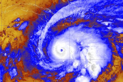
1 of 2 | Hurricane Melissa was upgraded to a Category 4 storm as it nears Caribbean islands, many of which have issues storm warnings and watches. Photo courtesy of NOAA
Oct. 24 (UPI) — Melissa was upgraded to a Category 4 hurricane as it made its way toward Jamaica, the National Hurricane Center said Sunday.
It is expected to strengthen to a Category 5 storm, causing catastrophic conditions for Caribbean nations.
The hurricane became a Category 4 storm with maximum sustained winds of 140 mph while moving west at 5 mph and positioned about 110 miles south of Kingston, Jamaica, and about 285 miles south-southwest of Guantanamo, Cuba, the National Hurricane Center reported in its 2 p.m. EDT update.
The storm had become a hurricane at 9 a.m. EDT on Saturday and was upgraded to a Category 3 hurricane by Saturday night.
It continues to gain strength and could cause life-threatening and catastrophic flash flooding and landslides in parts of Southern Hispaniola and Jamaica into early next week.
Currently, a hurricane warning is in effect for all of Jamaica.
Hurricane watch advisories are also in effect for the southwestern peninsula of Haiti from the border with the Dominican Republic to Port-Au-Prince and for the Cuban provinces of Granma, Santiago de Cuba, Guantanamo, and Holguin.
Accuweather Meteorologist Alex Duffus warned that entire communities could be cut off from aid and support for several days.
“Melissa’s slow movement over the mountainous islands greatly increases the risk of catastrophic flash flooding and deadly mudslides,” Duffus said. “This can quickly escalate into a humanitarian crisis, where a large number of people are in need of basic supplies such as food, safe drinking water, housing and medical care.”
A hurricane warning is in effect in Jamaica, while a hurricane watch is in effect for the southwestern tip of Haiti and the Cuban provinces of Granma, Santiago de Cuba, Guantanamo and Holguin.
A turn to the north and northeast is forecast on Monday and Tuesday.
“This remains a very serious situation, in terms of catastrophic rainfall, wind, and storm surge hazards for Jamaica, and preparations should be rushed to completion in the area currently under a Hurricane Warning,” NHC forecaster Jack Beven said in a discussion.
On the forecast track, Melissa is expected to move near or over Jamaica through into early next week, and it could be near or over eastern Cuba by the middle of next week and then head northwest in the Atlantic farther from the United States.
“It must be noted that there is very little practical difference in the overall impacts of a Category 4 or 5 landfall, and Melissa is expected to be at least that intensity when it moves over Jamaica,” Beven wrote in a discussion.
“Melissa should weaken as it interacts with Jamaica and Cuba, although it is still forecast to be a major hurricane when it nears Cuba. A faster weakening should occur after passing Cuba when the cyclone encounters strong shear over the southwestern Atlantic,” he wrote.
This would be the strongest direct landfall for the island since tropical cyclone record-keeping has been kept in the Atlantic Basin.
Tropical-force winds stretch outward to 115 mph from the center.
Rainfall of 15 to 30 inches through Wednesday is forecast for portions of southern Hispaniola, which includes Haiti and the Dominican Republic, and Jamaica, with a local maximum of 40 inches, the NHC said.
Eastern Cuba is expected to receive rainfall of 6 to 12 inches, with local amounts up to 18 inches into Wednesday.
“Life-threatening storm surge is becoming more likely along the south coast of Jamaica later in the weekend or early next week,” the NHC said.
Peak storm surge heights could reach 9 to 13 feet above ground level, near and to the east of where the center of Melissa makes landfall and be accompanied by large and destructive waves.
There also is a potential for significant storm surge along the Cuban coast next week.
Melissa is the 13th named storm of the season, and it’s the first in the Caribbean.
This season has seen few storms, which have warmed the Caribbean Sea, and the warm water is potential fuel for stronger and more dangerous storms.