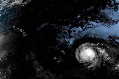
Hurricane Kiko was expected to continue on the path toward the Hawaiian Islands over the next several days, but it’s unclear to what extent it might impact the state. Photo courtesy of National Oceanic and Atmospheric Administration
Sept. 4 (UPI) — Hurricane Kiko continues to track in the general direction of Hawaii while maintaining its Category 3 status with 120 mph winds on Saturday afternoon.
Kiko weakened slightly and was located about 935 miles east-southeast of Hilo, Hawaii, and 1,135 east-southeast of Honolulu, while moving west-northwest at 12 mph, the National Hurricane Center reported in its 5 p.m. EDT update.
Hurricane-force winds extend about 25 miles from the storm’s eye, while tropical-storm-force winds extend outward by up to 80 miles.
The hurricane is expected to continue moving toward the west-northwesterly and gradually weaken over the next several days.
No coastal watches or warnings are in effect, but “interests in the Hawaiian Islands should monitor the progress of Kiko,” NHC forecasters said.
“Swells generated by Hurricane Kiko are expected to reach the Big Island and Maui by Sunday,” the NHC announced.
“These swells will gradually build and are forecast to peak along east-facing exposures of the Hawaiian Islands late Monday through midweek, potentially producing life-threatening surf and rip currents,” the NHC forecasters said.
Officials in Hawaii declared a state of emergency on Saturday to prepare for a possible strike by Kiko and other storm-related effects.
The state of emergency is in effect through Sept. 19, unless it is terminated sooner or extended beyond that date.
The storm formed on Sunday, making it the 11th named storm in the Eastern North Pacific this year.