Slow-moving Cat. 5 Hurricane Melissa nears Jamaica landfall
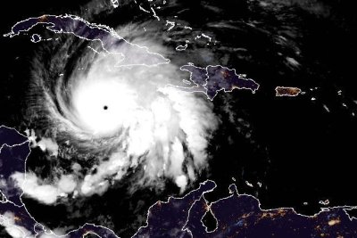
1 of 2 | Hurricane Melissa, a strong Category 5 storm, was expected to make landfall in southern Jamaica early Tuesday. Photo courtesy of NOAA
Oct. 27 (UPI) — Melissa, a strong Category 5 hurricane, neared landfall on the Caribbean island nation of Jamaica early Tuesday, where three people were already dead and amid fears of a humanitarian crisis.
The Dominican Republic, Haiti, Cuba and the Bahamas were to be later threatened with powerful winds, rainfall and storm surge.
The storm was expected to move near or over Jamaica’s southern coast Tuesday — the first hurricane to make landfall in the Caribbean this season.
The island, which has 2.8 million residents, was already experiencing damaging winds and heavy rainfall, threatening catastrophic and life-threatening flash flooding and landslides. The Ministry of Health and Wellness has reported three deaths and nearly 15 people injured while preparing for the storm.
The hurricane was situated about 115 miles southwest of Kingston, Jamaica, and about 290 miles southwest of Guantanamo, Cuba, the National Hurricane Center said in its 2 a.m. EDT update. It was moving north-northeast at 5 mph.
Melissa’s maximum sustained winds of 175 mph have not changed since the 2 p.m. update on Monday. Hurricanes are designated as the highest class when they reach 157 mph.
When Melissa makes landfall as a powerful major hurricane, it will be the strongest direct hit for the island since records have been kept in the Atlantic Basin.
“Catastrophic flash flooding and numerous landslides are expected through Tuesday,” NHC forecaster Richard Pasch said in a late Monday discussion about Jamaica. “The eyewall’s destructive winds may cause total structural failure, particularly in higher elevations, leading to widespread infrastructural damage, prolonged power and communication outages and isolated communities.”
The storm became a hurricane Saturday morning and was upgraded to a Category 3 major hurricane by Saturday night, then a Category 4 on Sunday morning and a Category 5 on Monday morning.
On Tuesday night or Wednesday, Melissa is anticipated to make a second landfall along Cuba’s southeastern coast, while still wielding major hurricane strength. It’s also expected to remain a hurricane when it reaches the Bahamas. Bermuda also could be threatened.
“After reaching Jamaica, a combination of land interaction and increasing southwesterly shear should cause some weakening, although Melissa is still forecast to be a major hurricane when it reaches Cuba,” NHC forecaster Jack Beven said in an earlier discussion.
“Once over the Atlantic, stronger shear should cause more substantial weakening, and Melissa is expected to become extratropical by the end of the forecast period as it interacts with a large baroclinic low over the north Atlantic.”
Catastrophic flash flooding and landslides in parts of southern Hispaniola and Jamaica were expected through early next week.
A hurricane warning was in effect for all of Jamaica; the Cuban provinces of Granma, Santiago de Cuba, Guantanamo and Holguin; and the southeastern and central Bahamas.
Hurricane watches were in effect for the Turks and Caicos Islands.
There was a tropical storm warning for Haiti and the Cuban province of Las Tunas and the Turks and Caicos Islands.
Hurricane-force winds extended up to 30 miles from the center, and tropical-force winds tended outward to 195 miles.
Rainfall of 15 to 30 inches through Wednesday was forecast for portions of Jamaica and an additional 6 to 12 inches for southern Hispaniola, which includes Haiti and the Dominican Republic, and Jamaica, with a local maximum of 40 inches, the NHC said.
“Catastrophic flash flooding and numerous landslides are likely,” NHC said.
Cuba is expected to receive rainfall of 10 to 20 inches, with local amounts up to 25 inches, into Wednesday, “resulting in life-threatening and potentially catastrophic flash flooding with numerous landslides,” NHC said.
Over the southeastern Bahamas, rainfall is forecast to total 5 to 10 inches into Wednesday with flash flooding in some areas.
Life-threatening storm surge heights could reach 9 to 13 feet above ground level, near and to the east of where the center of Melissa makes landfall and are expected to be accompanied by large and destructive waves, NHC said.
Along the Cuban coast late Tuesday and Wednesday, there is a potential for significant storm surge of 7 to 11 feet.
And in the southeastern Bahamas and Turks and Caicos Islands, there is the possibility of storm surge of 4 to 6 feet.
Melissa is the 13th named storm of the season and fifth hurricane. The other Category 5 storms in the Atlantic have been Erin and Humberto.
In September 2019, Hurricane Dorian had maximum sustained winds of 185 mph and destroyed the Bahamas islands, including Abaco Islands and Grand Bahama, as a Category 5 storm.
The all-time highest sustained measure was Hurricane Allen at 190 mph in August 1980 over the Yucatan Peninsula but weakened to a Category 3 when it struck south Texas.
The most destructive Category 5 storm in the United States was Hurricane Andrew in August 1992, with $27.3 billion in damage. Hurricane Michael, also a Category 5 storm, struck the less populated Florida Panhandle in October 2018.
The U.S. is not threatened this time.
Hurricane Gilbert struck Jamaica in 1988 as a Category 3 storm. The island could be battered for several hours as the eyewall moves slowly.