

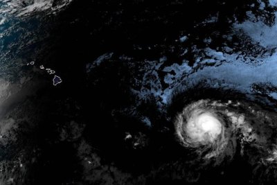
Hurricane Kiko was expected to continue on the path toward the Hawaiian Islands over the next several days, but it’s unclear to what extent it might impact the state. Photo courtesy of National Oceanic and Atmospheric Administration
Sept. 4 (UPI) — Hurricane Kiko weakened to a Category 3 hurricane late Thursday as it made its way northwest toward the general direction of Hawaii, forecasters said.
Kiko had reached Category 4 strength late Wednesday but weakened to 125 mph maximum sustained winds in the National Hurricane Center’s 3 p.m. HST update. Despite the weakening, the storm is still considered a major hurricane that could cause severe damage if it reaches land.
The eye of the storm was located about 1,360 miles east-southeast of Hilo, Hawaii, and 1,565 miles east-southeast of Honolulu. It was traveling west at 9 mph and was expected to continue in that direction and toward the northwest over the next several days.
“Kiko is forecast to approach the Hawaiian Islands during the early to middle portion of next week,” the NHC said in a statement Thursday.
“The risk of direct impacts from wind and rainfall is increasing. However, it is too soon to determine the exact location or magnitude of these impacts, and interests there should continue to monitor the progress of this storm.”
The NHC said swells generated by Kiko could reach the Hawaiian islands toward the end of the weekend, causing life-threatening surf and rip currents.
There were no weather watches or warnings in effect because it was well away from land Thursday.
The storm formed on Sunday, making it the 11th named storm in the Eastern North Pacific this year.