

Tropical Storm Humberto is forecast to become a hurricane early Saturday and a major one by Sunday night. Image by National Hurricane Center
Sept. 24 (UPI) — Tropical Storm Humberto, the eighth named storm of the 2025 Atlantic hurricane season, formed Wednesday afternoon and is forecast to become a hurricane by Saturday and ultimately a major one, the National Hurricane Center said.
In a 5 p.m. EDT posting, NHC said Humberto became a tropical storm with maximum sustained winds of 40 mph, which is 1 mph below the minimum to be classified as a tropical storm. Six hours later, NHC said it had maximum sustained winds of 45 mph. A storm became a hurricane with winds at least 74 mph.
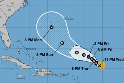
At 11 p.m., Humberto was about 505 miles east-northeast of the Northern Leeward Islands and was moving west-northwest at 12 mph.
NHC said the storm is expected to continue in the same direction over the next few days but with a lower forward speed.
“It may intensify into a hurricane late this weekend or early next week,” Alex DaSilva, AccuWeather lead hurricane expert, said.
NHC forecasters Richard Pasch and Eric Blake said in a discussion: “The system will probably become a hurricane in a couple of days, and then strengthen into a major hurricane.”
Humberto is forecast to pass between Bermuda and the U.S. East Coast.
“Towards the end of the forecast period, an approaching trough moving offshore the East Coast of the United States will erode the ridge and allow the system to turn more northward,” NHC forecaster Larry Kelly said in a discussion. “However, there is quite a bit of uncertainty with the forward speed and cross-track spread of the system.”
Tropical storm-force winds extend outward up to 105 miles, NHC said.
No coastal watches or warnings are in effect.
Of the eight named storms, two became hurricanes, both major.
In August, Erin intensified into a Category 5 hurricane with 160 mph winds spreading across a 500-mile area. It did not make landfall in the United States but caused dangerous surf, rip currents and coastal flooding along the East Coast, with the worst conditions in North Carolina and Virginia.
Gabrielle formed in mid-September and also became a major hurricane, a Category 4. In the 3 a.m. GMT update Thursday, Gabrielle had maximum sustained winds of 85 mph as a Category 1 storm and was about 855 miles west of the Azores.
Tropical Storm Chantal was the only storm to make landfall in the U.S. — South Carolina on July 6.