

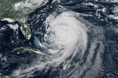
Hurricane Erin triggered state-of-emergency declarations in New Jersey and North Carolina as it passes along the East Coast on Thursday afternoon and creates life-threatening conditions that are expected to last through the weekend. Photo by EPA/NOAA
Aug. 21 (UPI) — Hurricane Erin’s effects have triggered state-of-emergency declarations in New Jersey and North Carolina as the storm system moves along the East Coast.
New Jersey Governor Phil Murphy declared a state of emergency Thursday afternoon, while North Caroline Governor Josh Stein declared one on Tuesday that remains in effect.
“Over the past couple of days, we have seen the effects of Hurricane Erin along the Jersey Shore in the form of dangerous rip tides,” Murphy said in a news release.
“As the storm moves past New Jersey over the next 23 hours, we are expecting high surf and rip currents, coastal and flash flooding, and a high erosion risk in parts of the state,” Murphy added.
North Carolina officials expect similar conditions to continue there after Hurricane Erin already has impacted Hatteras Island.
“Dangerous conditions, including rip currents and coastal flooding, are expected through the weekend,” Stein said in an online announcement on Thursday.
“With flooding peaking tonight, please avoid driving on roads with standing water,” he added.
An evacuation order was issued on Tuesday for residents and others along the Outer Banks.
Stein said state officials are monitoring the situation, and an emergency response team is working to keep roads clear and people safe.
Among emergency preparations, the North Carolina National Guard is on standby, and the state’s emergency response team has search-and-rescue teams ready to deploy if needed.
State Highway 12 on Hatteras Island is closed due to extensive ocean overwash and dune breaches in multiple locations, according to Dare County, N.C., officials.
The northern ends of Hatteras Village and Buxton, and along Pea Island, are especially impacted by the hurricane.
North Carolina Department of Transportation crews are working to clear sand and water from the state highway and repairing damaged dunes.
The highway will stay closed until NCDOT officials say it’s safe to travel on the roadway.
The Category 2 Hurricane Erin had maximum sustained winds of 100 mph while positioned 370 miles east-northeast of Cape Hatteras, N.C., late Thursday afternoon, according to the National Hurricane Center.
Erin is moving northeasterly at 20 mph and away from the East Coast, but its effects include storm surges of between 2 feet and 4 feet and related flooding along coastal areas from North Carolina to Sandy Hook, N.J.
The storm system also is creating dangerous rip tides alongmuch of the East Coast, which makes swimming very dangerous.