

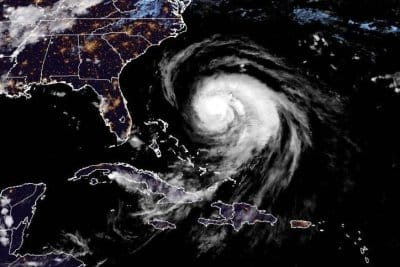

Hurricane Erin had maximum sustained winds of 105 mph Tuesday evening, and was expected to cause life-threatening rip currents along the U.S. east coast. Photo courtesy of the National Oceanic and Atmospheric Administration
Aug. 18 (UPI) — Hurricane Erin was taking aim at the U.S. East Coast on Tuesday evening, according to forecasters who are warning Americans of life-threatening rip currents along beaches that could persist for days.
The storm was located about 585 miles southwest of Bermuda and 540 miles south-southeast of Cape Hatteras, N.C., the National Hurricane Center said in its 11 p.m. EDT update.
Erin had maximum sustained winds of 100 mph, a Category 2 hurricane on the Saffir-Simpson Hurricane Wind Scale.
It was moving north-northwest at 12 mph.
A storm surge warning was in effect for from Cape Lookout to Duck, N.C., while a tropical storm warning was in effect for Beaufort Inlet to Duck, including Pamlico and Albemarle sounds.
North of Duck, N.C., to Chincoteague, Virginia, was under a tropical storm watch, as was Bermuda.
“On the forecast track, the center of Erin will pass to the east of the Bahamas tonight, and then move over the western Atlantic between the U.S. east coast and Bermuda on Wednesday and Thursday,” the NHC said.
Erin has been pummeling the Turk and Caicos, which are expected to see diminishing rainfall this evening, as should the Bahamas, the forecasters said, as they predict heavy rainfall for North Carolina starting Wednesday night and into Thursday. A potential 1 to 2 inches of rainfall is possible, they said.
Of greater worry are swells generated by Erin, which have the forecasters expecting life-threatening surf and rip currents affecting the Bahamas, Bermuda, Atlantic Canada and the U.S. east coast over the next several days.
“Beachgoers in those areas should follow advice from lifeguards, local authorities and beach warning flags,” the NHC said in a discussion on Erin.
“Storm surge flooding and tropical storm conditions are expected in the North Carolina Outer Banks beginning late Wednesday or Wednesday night, where tropical storm and storm surge warnings are in effect. The storm surge will be accompanied by large waves, leading to significant beach erosion and overwash, making some roads impassable.”
The season’s first Atlantic hurricane reached Category 5 status Saturday morning, the highest classification, after rapidly intensifying overnight Friday, when it became a Category 1 hurricane, the year’s fifth named storm.
Erin dropped to a Category 4 and then a 3 overnight into Sunday, but regained Category 4 strength late Sunday before again losing strength.
Erin became the first hurricane of the 2025 Atlantic storm season Friday morning.
There have been four named storms so far this season in the Atlantic. Tropical Storm Chantal caused major flooding in North Carolina but has been the only one of the four to make landfall in the United States this year.
The Atlantic hurricane season began on June 1 and ends on Nov. 30. The peak hurricane season runs from mid-August through September and into mid-October.
Ninety-three percent of hurricane landfalls along the U.S. Gulf Coast and the East Coast have occurred from August through October, the Weather Channel reported, citing data from the National Oceanic and Atmospheric Administration
Last year at this time, there had also been five named storms.